
Blog
Outdoor adventures and in-the-field photo shoots …
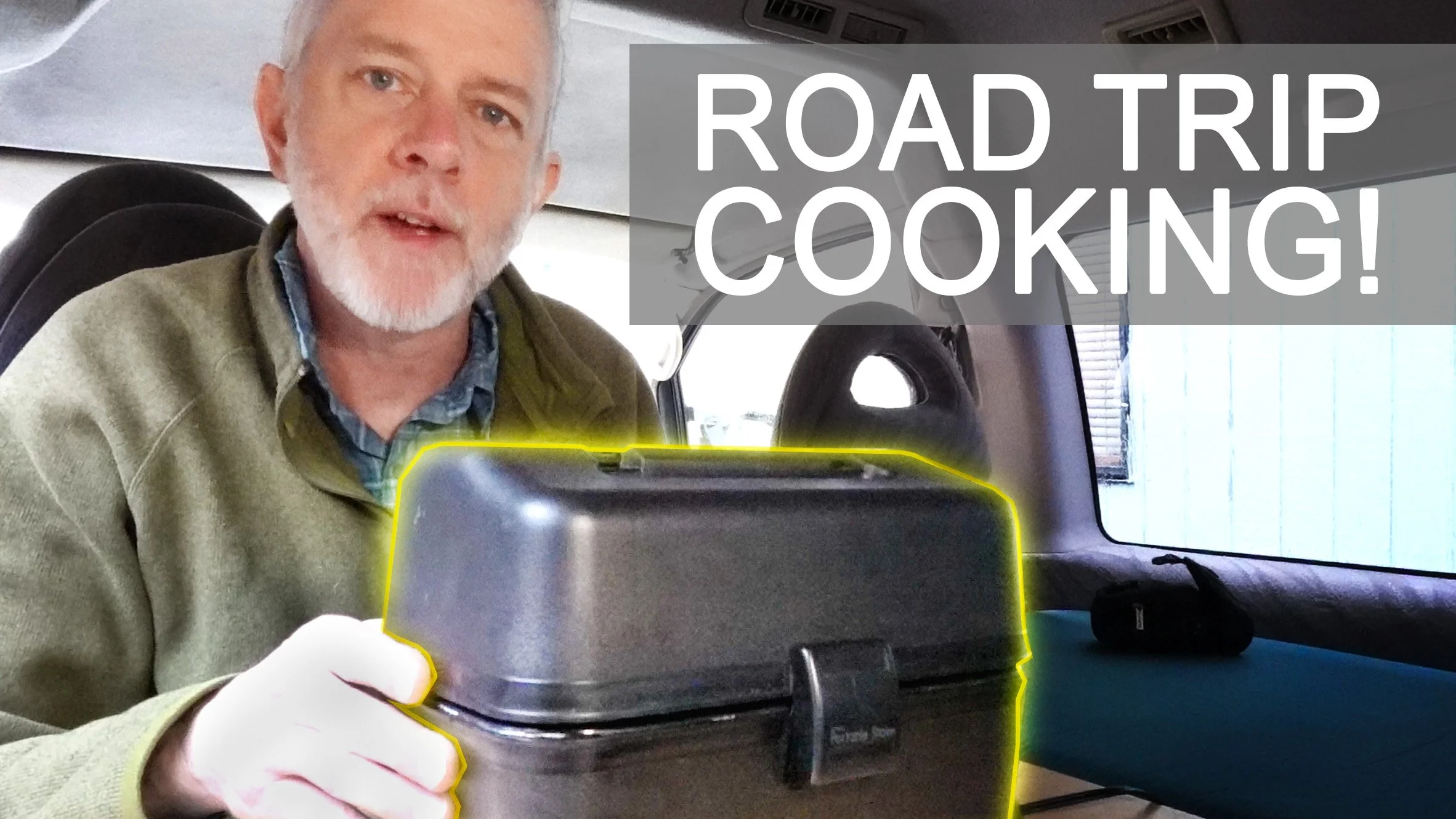
My Favorite Road Trip Cooking Accessory
Today I’m sharing my favorite cooking accessory for car camping and van camping: my lunch box oven! After a long drive, there’s nothing better than pulling into camp and having a delicious hot meal ready to eat! In this video, I introduce cooking in your lunchbox oven and several of my favorite recipes, including lasagna, beef & potatoes, chicken & sweet potatoes, meatloaf (my favorite!) and ranch/bacon chicken (also pretty damn good!).
![John River Packrafting Adventure [Video]](https://images.squarespace-cdn.com/content/v1/67a92e4acae22e2e88845e6b/67ffa512-5164-45bb-91ed-b419b6cbbac2/john-river-alaska-packrafting-adventure.jpg)
John River Packrafting Adventure [Video]
The John River flows 135 miles through remote wilderness from its headwaters in the Nunamiut village of Anaktuvuk Pass, through Alaska’s Brooks Range and Gates of the Arctic National Park, to its confluence with the Koyukuk River, just down stream of the village of Bettles. We float it all over 9 days, with white water up to Class III.
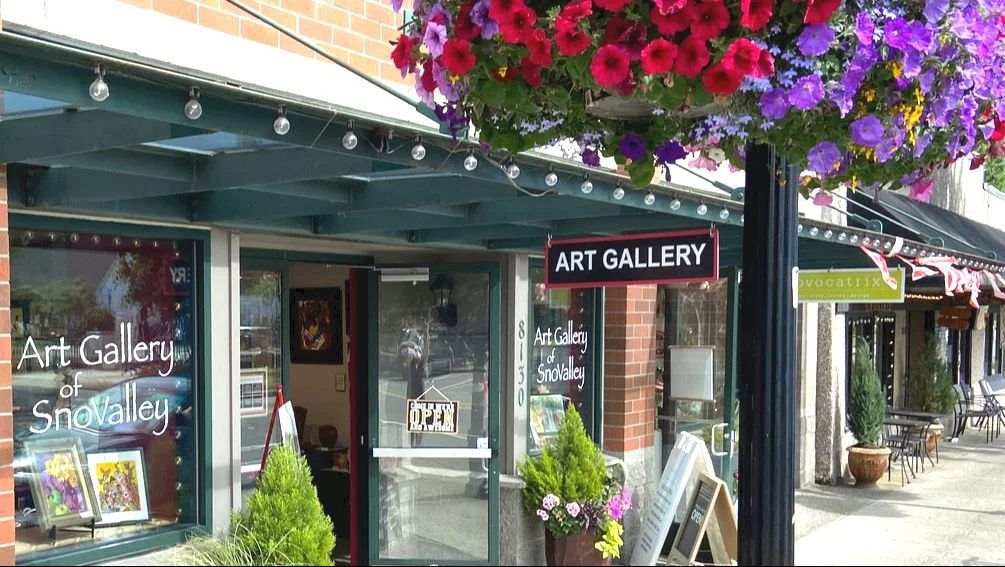
Now Exhibiting at Art Gallery of SnoValley
I’m pleased to be joining the artist-run Art Gallery of SnoValley in historic downtown Snoqualmie. If you are in Washington State’s Puget Sound region, come visit the gallery to see paintings in a variety of media, designer jewelry, art glass, woodwork, ceramics and sculpture created by local artists, and now including fine art prints by yours truly!

Inverter Installation
Installing a 375W Victron inverter in my 1995 Mitsubishi Delica L400 campervan to charge my Bluetti battery bank.

18 Month Delica Campervan Updates
In this post, I share the upgrades I've made to my 1995 Mitsubishi Delica L400 camper van over the last 18 month, including addition of an electrical battery bank, 100 watt solar panel, power inverter and portable refrigerator. All these components have worked very together very well over 80 days of camping in the last 18 months.

Ruby Beach Makes Lonely Planet’s “100 of the World’s Most Incredible Beaches”
Well known travel publisher Lonely Planet named Ruby Beach as one of the top 100 beaches of the world in its new book Lonely Planet Best Beaches: 100 of the World’s Most Incredible Beaches. Ruby Beach was only one of two Pacific Northwest beaches to make the list … the other being Cannon Beach in Oregon.

Great News for Salmon
New research by scientists at King County, Western Washington University and University of Washington finds a roadside soil treatment capable of removing 6PPD-quinone from tire dust in runoff water, a chemical which is deadly to salmon in urban streams.

Boulder River Wilderness
A short video photographing waterfalls along the Boulder River Trail in the central Cascade Mountains of Washington State. This is a trail I return to again and again for its easy access, beautiful forests and towing waterfalls. I was lucky enough to shoot these falls on an early spring morning with good water flow just before a wind and rain storm came in.

Viewing Images of Nature Reduces Perception of Pain
This new article Nature Exposure Induces Analgesic Effects by Acting on Nociception-Related Neural Processing, published in Nature Communication, highlights new science demonstrating the positive benefits of viewing images of nature.
![Washington Coast Photoshoot [Video]](https://images.squarespace-cdn.com/content/v1/67a92e4acae22e2e88845e6b/1740949784208-40Y5CYEF14NS4UIBZ106/AHS4-shi-shi-beach.jpg)
Washington Coast Photoshoot [Video]
Winter photoshoot at Shi Shi Beach out on the Washington Coast, Olympic National Park
![South Nahanni River Packrafting Adventure [Video]](https://images.squarespace-cdn.com/content/v1/67a92e4acae22e2e88845e6b/1739169644008-641QYNZ2PZW96BKR38WP/south-nahanni-packrafting-adventure.jpg)
South Nahanni River Packrafting Adventure [Video]
The South Nahanni River flows 565 kilometers through remote wilderness from its headwaters in the heart of the Mackenzie Mountains to it’s confluence with the Liard River in Canada’s Northwest Territories. We float it all, on this river Bill Mason called "the greatest canoe trip in the world."

Nature TTL: How to Photograph the Backyard Birds of North America
Check out my article just published in on-line magazine Nature TTL on how to photograph birds in your own backyard

Campervan First Camping Trip
It’s finally time to take my newly converted 1995 Mitsubishi Delica L400 campervan on its first trip! We are off to 4 days of camping in an Olympic National Park rainforest for some hiking and photography.

DIY Campervan Floor Mat
A quick build to make a rubber floor mat to fit my 1995 Mitsubishi Delica L400 campervan.

Campervan Ventilation & Heating
We set up a portable diesel heater and rear window ventilation fans in an old 1995 Mitsubishi Delica L400 to keep our campervan conversion warm and dry on cold rainy Northwest winters.

DIY Magnetic Bug Screens for Campervan
We build magnetic bug screens to cover the back windows of the Mitsubishi Delica L400 to keep those pesky mosquitoes out.

Delica Campervan Roof Rack & Awning
We install a Rhino Rack onto a high roof 1995 Mitsubishi Delica, along with a Yakima awning. We also develop and build a smaller “quick deploy” awning to cover just the slider door area when the larger awning is not necessary.

Delica Campervan Interior Conversion
We convert the interior of this old Mitsubishi Delica L400 Space Gear into a campervan for outdoor photography adventures.